
Basingstoke to New Alresford, 24 July 2015
St James’ Way 2: the way of the sluggard is blocked with thorns
I ate breakfast at a café on a trading estate on the way out of Basingstoke for half the price of the hotel one. Then I retraced my steps of the day before. It wasn’t nearly so soul-destroying as it might have been, because it wasn’t the same day and it wasn’t due to a mistake. It was just part of the plan; I knew I was going to have to anyway. I rejoined the route back in Worting. The path climbed steeply away from the main road and took me across another annoying brambly field – the more so because it turned out that I didn’t actually need to go through the brambles – and over the railway. I got slightly lost in a residential area and finally found my way onto the route of a Roman road, with a field on one side, and what I described in my diary as ‘boring houses’ on the other. (‘They’re all homes, Dorothy,’ someone told my grandmother, when she was being snobbish.) Kind ladies with dogs redirected me when I got confused.
It had been drizzling all morning. Now it started raining properly. The route led me into beech woods, where tree roots bulged up in the chalky path. I saw glimpses of brightness through the gloomy trees, and almost thought the sun had come out, but it was just stubble of wheat fields throwing white-gold up towards the grey sky. I came out of the woods, through a farmyard, and back onto the road.
The next challenge was crossing the A30 – confusing and terrifying, like getting from the bottom right hand corner of a letter X to the top left hand corner, if the letter were made of a major road. I walked through more woods, crossed a bridge over the M3 and proceeded up a conference centre’s service road in ever-heavier rain. My mother texted me to see if I had any ideas about songs we might sing at my birthday party, so she could write the music out for the band. I started making a mental list. At the next pub, I told myself, I’d get my notebook out and write them down. The thought sustained me through a tedious stretch of road walking.

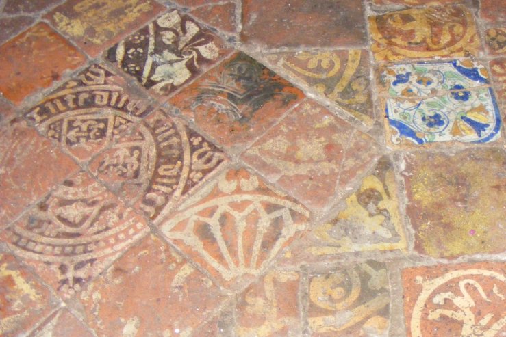
The next pub was in Dummer, and was not yet open. A couple of squares of chocolate in the comparative shelter of the church lychgate had to suffice. I pushed on towards Preston Candover down a concrete path between wheatfields – meeting, as one of them remarked, far more people in the rain than were to be seen out in the sun the previous day. It was another four miles, and it was really, really raining now. I retained enough sense of my purpose to look into a disused church and admire the floor tiles, but my interest was ebbing.
On the bright side, the Preston Candover pub was open. Even better, it had started serving lunch about ten minutes before I got there. Spanish menu; Aussie barmaid. Clientele: wellingtons, gin and tonic, and spaniels. Grilled mackerel, new potatoes, fennel and watercress salad, pistachio sponge sundae. It was expensive for a pub lunch, and more than I’d meant to spend, but well worth it both for the food and the chance to sit inside and drip gently.
Sadly, I couldn’t sit inside all day. I set off again. Wetter and wetter and wetter. One utterly obnoxious field that left my boots caked three inches thick, a hole in the hedge that ripped my rucksack cover off, mud mud mud. The great thing about being out in weather that no sane person would be out in is that you can scream as loud as you like without fear of people hearing. So I did. Too much road walking. I decided that I was too wet to care about the 12th century church of St James at Upper Wield, and stomp stomp stomped along the Oxdrove Way, which goes on for ever. FOR EVER. Four miles, apparently. Anyway, when I finally got out at Old Alresford I’d had enough. I abandoned the guidebook, which should have been a huge mistake. Certainly it meant that I had to follow the main road into Alresford, which was slightly terrifying in the gathering gloom and the pouring rain.
I’d booked to stay in the Swan Hotel, which had seemed to my teenage self to be the height of luxury when my godfather had held a birthday party there about twelve years previously. Fortunately, it wasn’t so luxurious that I got kicked out for being soaked to the skin. In fact, it was a perfectly standard country coaching inn. I couldn’t help but feel that the kitschy red paint and monochrome photo wallpaper décor was a mistake in a country coaching inn with exposed beams, but I wasn’t going to complain. There was a bath.
When I’d had a bath (I couldn’t possibly get any wetter, this was at least warm, and when I’d finished washing myself I washed my socks in it) and dried off, I took myself, my diary and my map down to the bar, and ordered a pint and a burger. Then I phoned my father, and discussed party logistics and how to get from Alresford to Winchester, assuming that I could actually walk the next day.
My father is very good at maps, and spent most of his early life in Winchester and its surroundings. He found his own Ordnance Survey Winchester, New Alresford and East Meon, and we worked out a sensible route that would take me past my grandparents’ grave, and also the Angry Red Eye of the Almighty. And you’ll just have to wait until next time to find out what that is.
